Regulatory
The 2020 Colorado Revised Statutes (CRS) Title 33 – Parks and Wildlife directs regulatory authority to the Colorado Parks and Wildlife (CPW) Department to protect, preserve, enhance, and manage all game and nongame species of wildlife in Colorado. Some of the species within the Project area are regulated under CRS Title 33, managed by the CPW and have various levels of regulatory protection and/or restrictions on activities that can occur within their habitat.
Baseline Conditions
Information regarding wildlife in the Project area was gathered from personal observations of the author, and by contributing resource experts (Craig Grother, wildlife biologist USFS, retired; Chris Hensley, wildland firefighter USFS herpetological citizen scientist). The author, a wildlife biologist, lives in the Project area and makes observations of wildlife throughout the year. General observations of habitat types and vegetation coverage in and surrounding the Project area were made using Google Earth imagery and corroborated during field investigations of the east array area, and from outside of the west array area boundary along Lone Cone Road. The Colorado Natural Heritage Program (CNHP) Colorado Conservation Data Explorer (CODEX) was also queried for information on wildlife in the area. CODEX is an online program that synthesizes data from multiple authoritative sources including: CNHP, CPW, Bird Conservancy of the Rockies, U. S. Fish and Wildlife Service (USFWS), and NatureServe. The CODEX report is provided in Appendix D.
The proposed Project area encompasses a total of 1009.4 acres. The dominant habitat type in the Project area is two-needle pinyon-Utah juniper (Pinus edulis - Juniperus osteosperma) shrub dry-mesic woodlands and sagebrush and sandsage scrub. Some Ponderosa pine (Pinus ponderosa) occurs sporadically throughout the Project area. The Project area has a very open canopy and an understory of fairly open mesic shrubs, herbaceous vegetation and grasses. The general setting of the surrounding area is undisturbed rural and agricultural land cover. Within that setting, the Project site provides habitat for numerous species of game and nongame wildlife and connects habitat to the south, east and west.
Field investigations were conducted on October 3 and 4, 2023, and January 6, 2024. The east array area was surveyed via walking through the entire area and making observations of habitat types and wildlife. The Section 1 east array area encompasses pinyon-juniper forest, sagebrush scrub, riparian zones, a spring, and small ponds. The Gurley Ditch riparian zone, dominated by Gambel oak, narrowleaf cottonwood, and coyote willow, transects the entire tract. The South Lateral Ditch runs along the south edge of the tract. There is a freshwater spring and two small ponds located near the western edge of the tract and three large wetland areas (see Figure 5). The east array area is owned by the Colorado State Land Board and is currently being leased for: 1) agriculture - to keep a small herd of bulls; 2) recreation – hunting; and 3) renewable energy planning solar. Surrounding areas are privately owned; it is bounded to the north, east and west by section roads and open agricultural lands (privately owned, pasture); it is bounded to the south by mostly undeveloped pinyon-juniper woodlands. According to the CODEX mapping program, disturbance levels on the east array area are classified as “low” to “moderate”;
Field investigations of the west array area or Section 2 were conducted on October 3 and 4, 2023; observations were made from outside of the existing perimeter fence along Lone Cone Road to the east and from the north on neighboring property (with permission of the landowner). Habitat types and vegetation observed indicate that the dominant habitat type in Section 2 is pinyon-juniper forest with open areas of sagebrush scrub and herbaceous vegetation. Aerial imagery (Google Earth, 2023) indicates that pinyon-juniper/sagebrush habitats are the dominant land cover type(s) throughout the west array area. A powerline ROW transects the area. The tract is bounded to the south by similarly undeveloped pinyon-juniper forests, to the east by pinyon-juniper woodlands with some large-tract (>40-acre) residential/small farm development, and to the north by open residential/agricultural lands (pasture). To the west is the Ed Joe Draw, a steep riparian zone of the Cone Ditch, forested in old growth Ponderosa pine. The west array area is privately owned; there are no permanent dwellings on the property. Surrounding areas are privately owned. According to the CODEX mapping program, disturbance levels on the west array area are classified as “low” to “none or minimal”.
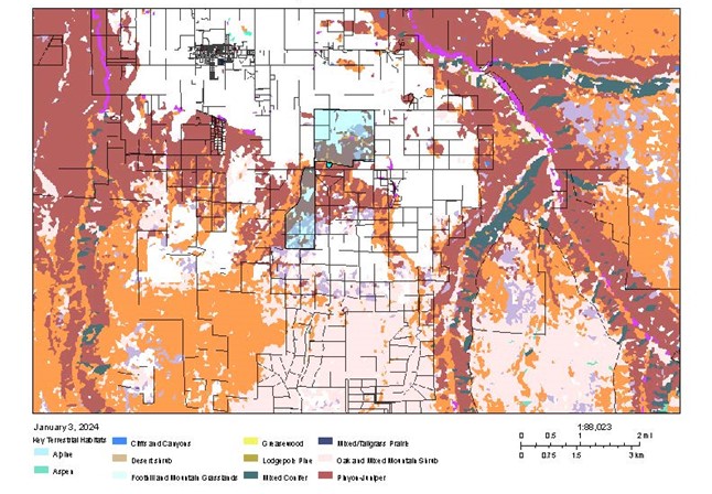
The CODEX mapping program was used to identify landscape-level habitat classifications, land cover, and surface ownership to provide a context of the Project affect within the landscape. The proposed Project site is located in a transition zone where residential/agricultural surface use gives way to less developed (very widely spaced residential) areas within native wildland habitats. Habitat within the proposed Project area provides breeding, foraging and shelter for numerous wildlife species and provides connectivity of habitat to the south, east and west, providing a corridor for wildlife movement between these areas. The proposed Project site is located within one mile of two private conservation areas and USFS lands, and within two miles of BLM lands and the San Miguel River corridor—identified by the Audubon Society as an Important Bird Area (Appendix B, Map B-2). CODEX maps provide a landscape-level reference of the size of the proposed Project within the surrounding landscape, and the potential for land cover conversion should the proposed Project be implemented. A map of the land cover types is provided in Figure11. Additional resource maps are provided in Appendix B and include:
- Topography of the Project area
- Land surface features and ownership
- Land cover types
- Key terrestrial habitats
- Landscape disturbance classes
Wildlife species observed in the Project area include:
Rocky Mountain Elk (Cervus canadensis) - Spring of 2023, 5 cows calved on the SLB property; elk observed using the proposed east array area as wintering habitat (observations of the author). The CODEX database identifies the Project area to be within 1) overall range; 2) winter range; 3) elk winter concentration area - a high priority habitat. CPW restrictions: Elk severe winter range-no permitted or authorized activities from December 1 to April 30; Surface density limitations of one pad per square mile and less than one linear miles of route per square mile (640 acres).
Mule Deer (Odocoileus hemionus) – a resident population of mule deer occur in the Project area year-round and use the area for forage, breeding and sheltering (observations of the author). The area provides shelter and forage especially for females and fawns. The CODEX database identifies the Project area to be a mule deer concentration area. CPW restrictions: No permitted or authorized activities from December 1 to April 30; Surface density limitation of one pad per square mile and less than one linear mile of routes per square mile (640 acres).
Mountain Lion (Puma concolor) – mountain lions and sign (tracks and scat) have been observed in the Project area and within close proximity on several two occasions in 2023.
American Black Bear (Ursus americanus) ̶ move through the area and likely use the Project area for foraging and occupancy throughout the spring and summer, and in fall when gambel oak acorns are abundant.
American Badger (Taxidea taxus) ̶ resident in surrounding areas. More abundant in areas where prey such as prairie dogs and ground squirrels are available.
Red Fox (Vulpes vulpes) – Burrow and tracks observed within east array area; many sightings in fields and scrublands surrounding the proposed Project area. Red fox is an opportunistic omnivore, preying on small mammals, carrion, birds, insects, fruit, human refuse, etc. Rabbits and mice are common prey.
Coyote (Canis latrans) – Observed in surrounding areas. Coyote likely occurs in Project area as a resident species due to availability of suitable habitat and limited access by humans. Coyote are opportunistic omnivores that prey on small mammals, carrion, insects, birds, and refuse.
White-tailed jack rabbit (Lepus townsendii) – observed in the sagebrush habitats within the proposed east array area throughout the year. Important prey for raptors, fox, coyote, mountain lion.
Desert cottontail (Sylvilagus audubonii) - observed in the Project area and surrounding areas throughout the year. Important prey species for raptors, fox, coyote, mountain lion.
Striped skunk (Mephitis mephitis) – observed along streamside zones in areas surrounding the Project site. Active all year; Project area provides suitable foraging, denning and breeding habitat.
Racoon (Procyon lotor) – tracks and scat observed along streamside zones in areas surrounding the Project site. Active all year; Project area provides suitable foraging, denning and breeding habitat.
Sagebrush scrub, juniper woodlands, and extensive riparian and wetland habitat within the proposed Project area provides a rich and diverse ecosystem to support a variety of reptiles and amphibians. Reptiles observed in the proposed Project area include: greater short-horned lizard (Phrynosoma hernandesi), sagebrush lizard (Sceloporus graciosus). Other reptiles and amphibians expected to occur in the proposed Project area include:
- Barred Tiger Salamander Ambystoma mavortium
- Woodhouse's Toad Anaxyrus woodhousii
- Western Whiptail (Painted Desert) Aspidoscelis tigris
- Plateau Striped Whiptail A. velox
- Striped Whipsnake Coluber taeniatus
- Western Rattlesnake Crotalus oreganus
- Eastern Collared Lizard Crotaphytus collaris
- Desert Nightsnake Hypsiglena chlorophaea
- Western Milksnake Lampropeltis gentilis
- Northern Leopard Frog Lithobates pipiens
- Smooth Greensnake Opheodrys vernalis
- Gophersnake Pituophis catenifer
- Western Chorus Frog Pseudacris triseriata
- Plateau Fence Lizard Sceloporus tristichus
- Ornate Tree Lizard Urosaurus ornatus
- Wandering Garter Snake Thamnophis elegans ssp. vagrans
The diversity of habitat types in the proposed Project area provides plentiful high-quality habitat for an abundance of invertebrate species that, along with the biotic environs of the soils in the area, provide the basis for the food chain and the diversity of wildlife in the area. The wetland areas within the proposed east array area provide a unique and extraordinary resource within the setting of the shale deserts and sedimentary basins of the Colorado Plateau ecoregion—a region typified by xeric species, low annual precipitation and sparse surface waters. Wetlands play an integral role in the ecology of the region. The combination of shallow water, high levels of nutrients and primary productivity is ideal for the development of organisms that form the base of the food web. Wetland areas such as those within the east array provide critical habitat for the reproductive life cycle of invertebrate species. Insect species form the prey base for many vertebrate species and make up a large part of the pollinator niche—critical to the health and functioning of ecosystems, both local and regionally. Many species rely on wetlands for food, water and shelter; especially during migration and breeding. The CODEX report, provided in Appendix D, identifies numerous other species that have potential to occur in the proposed Project area.
Consequences
Construction and Operation/Maintenance.
Construction of the Project would result clearing and permanent loss of 580 acres of native pinyon-juniper sagebrush scrublands and fencing/exclusion from 1009.4 acres of habitat for numerous terrestrial game and non-game, special status (see Sections 3.6, 3.9, 3.10), and non-status wildlife species and migratory birds (see Section 3.7). As depicted by Figure 11, the pinyon-juniper sagebrush land cover stretches east to west across the region connecting habitat along the San Miguel River corridor and BLM lands to the east with expansive USFS lands to the west. The SLB tract (the proposed east array area) encompasses the northernmost contiguous tract of pinyon-juniper sagebrush habitat in the area. The proposed east and west array areas together would fragment this habitat type and create a fenced barrier running north-south for approximately 2.25 miles that would bisect the pinyon-juniper sagebrush land cover type and prevent wildlife movement through the area.
Direct effects would include injury or mortality to individuals or wildlife species from habitat disturbance (i.e., vegetation clearing, excavation, trenching, soils compaction) and from collision/contact with construction equipment and/or Project facilities and equipment. Solar panel arrays have been shown to increase mortality to bats from collisions and electrocution. Exposure to predators, stress and increased mortality from disturbance and removal of vegetation and habitat are also likely. Direct effects could also occur from herbicides (used properly or improperly) including death, damage to vital organs, decrease in body weight, decrease in healthy offspring, and increased susceptibility to predation, depending on exposure time and amount. Secondary poisoning could also affect predators that ingest affected prey species. Workforce traffic could also increase vehicle-wildlife collisions. Indirect effects include audial and visual disturbances during construction and long-term maintenance that would deter wildlife and migratory birds from utilizing adjacent areas.
The resultant loss of pinyon-juniper sagebrush scrublands would be locally significant due to the size of the site and because the location of the site within the landscape. Figure 11 depicts the proposed Project site and the change in key terrestrial habitats that would occur should the Project be implemented. The Project would remove 580 acres and fragment pinyon-juniper, sagebrush and sandsage habitat that currently provides breeding, forage and shelter for resident wildlife and also provides a corridor for wildlife movement between areas to the south, east and west of the proposed Project site. Project fencing would exclude terrestrial wildlife and create a barrier to seasonal movement of elk and mule deer. Implementation of the Project would result in severe reduction of available habitats in the landscape, fragment habitat and create new edge effects within the landscape, and reduce total available habitat on Wright’s Mesa and within the region. As depicted by Figure 11, the fenced Project site would remove a significant amount of habitat from the available habitat in the area and the proposed land cover use would result in a substantial change of habitat value within the landscape.
The Project site is located within close proximity to USFS lands, BLM lands, private conservation areas, and the San Miguel River corridor, which has been identified by the Audubon Society as an Important Bird Area and by the Colorado Natural Heritage Program as potential conservation area due to high to moderate biodiversity. Excluding this area from the available wildlife habitat would create further disparity between available habitat, cutoff essential corridor habitat between areas along the San Miguel River to the east and areas to the west on USFS and BLM lands, and reduce the overall quality of habitat in surrounding areas.
The proposed Project would create an immediate and significant change in percentage of vegetated land cover to industrial use, reduce habitat availability and suitability, fragment existing habitat types, and diminish various habitat values (i.e., wintering range, breeding range, concentration area, nesting, etc.) in the Project area and on the landscape level. Loss of habitat has been widely recognized as the number one reason for decreasing animal populations and species diversity for at least half a century. Fragmentation has been shown to reduce bio-diversity by 13 to 75% and impairs key ecosystem functions by decreasing biomass and altering nutrient cycles. Effects are greatest in the smallest and most isolated fragments, and they magnify with the passage of time (Haddad et al., 2015).
No Action Alternative
The No Action Alternative would result in no impacts to the wildlife. Conditions in the area would continue as is.