Regulatory
The Soil and Water Resources Conservation Act of 1977, as amended, provides the USDA NRCS authority for the conservation, protection, and enhancement of soil, water, and related natural resources. Farmland Protection and Policy Act, 7 U.S.C. 4201, was enacted in 1981 to minimize the loss of prime farmland and unique farmlands as a result of Federal actions by converting these lands to nonagricultural uses. Prime farmland is farmland that has the best combination of physical and chemical characteristics for producing food, feed, forage, fiber and oilseed crops, and is also available for these uses. Unique farmland is used for production of specific high-value food and fiber crops; it has the soil quality, location, growing season, and moisture supply needed to economically produce sustained high quality or high yields of specific crops.
Baseline Conditions
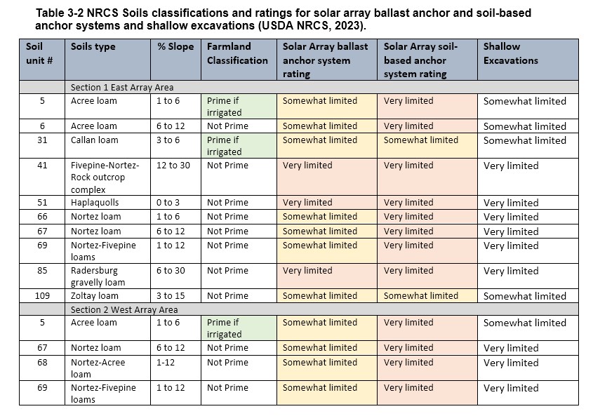
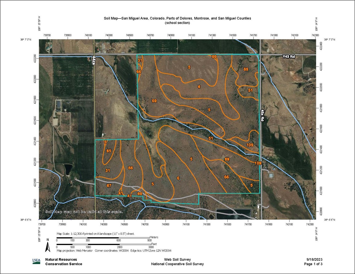
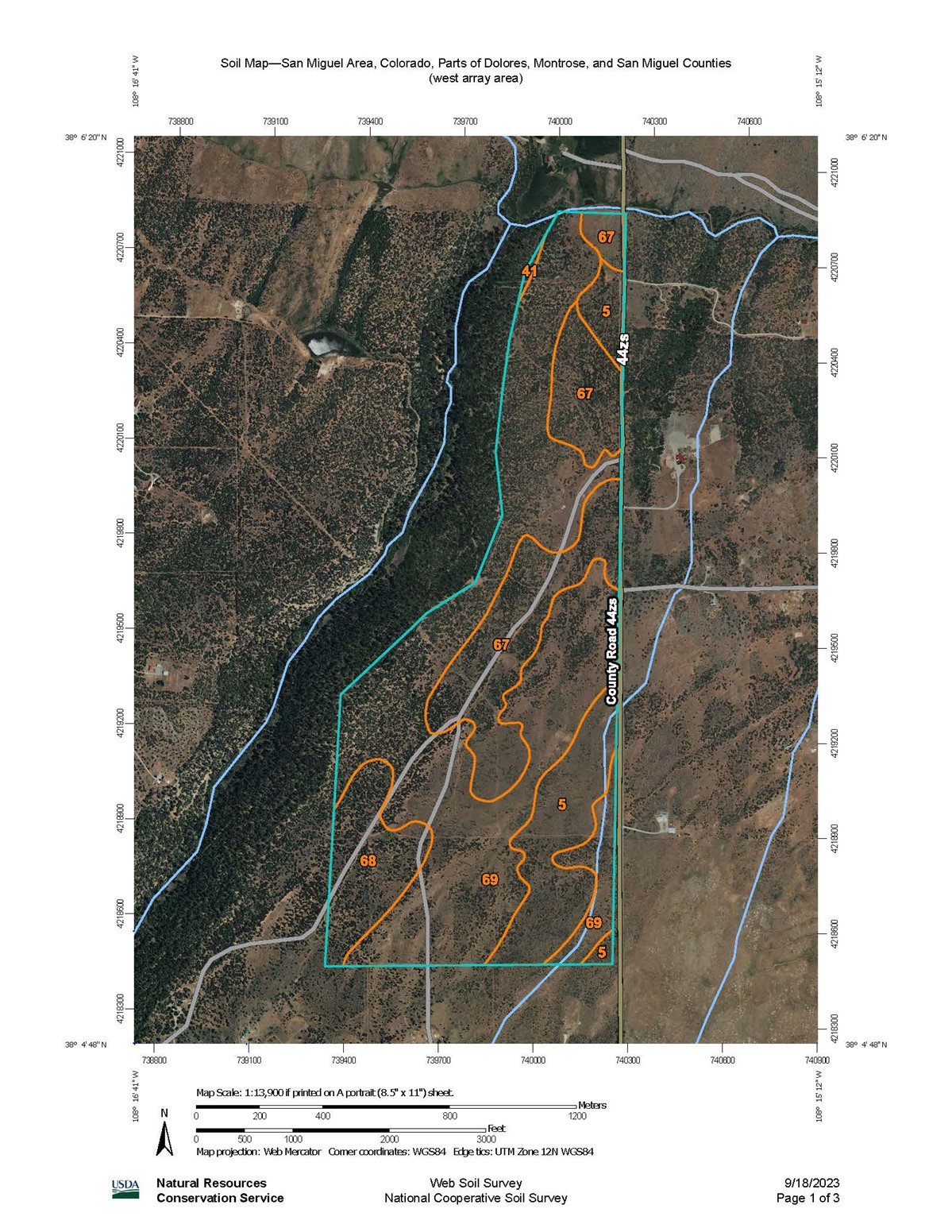
The soils in the Project area were identified and mapped (Figures 9 and 10) using the USDA NRCS Web Soil Survey (USDA, 2023). The Web Soil Survey provides land classifications (i.e., prime or unique farmlands) and information regarding soils properties such as erosion rates and hydrologic qualities, which can be affected by construction and excavation, as well as shrink-swell capacity and chemistry which can limit Project objectives. The Web Soil Survey provides information ratings for building site development, including suitability ratings for anchoring systems for solar arrays. The purpose of this analysis is to provide a general overview of the soil types and properties in the Project area.
Soil types in the proposed Project area were identified and rated for farmland and ecological site characteristics, wind erodibility, and suitability/limitations for shallow excavations, and solar array anchoring systems. Table 3-2 lists soil types found in the proposed Project area with farmland classifications and suitability ratings for solar array anchoring systems. Soils units 5-Acree loam and 31-Callan loam are classified as prime farmland if irrigated. Soils in the proposed Project area are classified as very limited for soil anchoring systems and somewhat limited for ballast anchoring systems. NRCS soils resource reports are provided in Appendix G.
Note: The Web Soil Survey is an ARC GIS-based mapping program. An ARC GIS-compatible shapefile of the Project footprint was not available to use with the program. As such, the soils maps developed for this analysis were drawn using a polygon tool in the Web Soil Survey program and do not represent the exact dimensions of the Project, the specific footprint of the east or west array sections, or specific location of any of the components included in the preliminary design of the Project. These soils maps are intended to be general overview maps that encompass the proposed Project footprint, but that do not represent exact acreage or the final design, and are presented with the express purpose of providing general information of soils classifications, capabilities and limitations relevant to the proposed Project.
Consequences
Construction activities would disturb most if not all of the soils within the proposed 580-acre Project site. Excavation, trenching, backfilling and compaction from vehicle and equipment traffic will result in adverse impacts to soil structure, soil chemistry and soil biotics. Surface disturbance would increase potential for erosion, especially during the construction process when soils will be disturbed and exposed to wind and precipitation. Some areas of soil will be permanently lost due to surface treatments (i.e., concrete foundations, gravel access). Many areas would incur severe compaction from repeated passes of construction traffic, changing soils structure and subsurface hydrology. Soils and topsoil would be lost due to wind erosion. Project-related impacts are expected to be short- and long-term direct adverse effects to soils.
No Action Alternative
Wind and water erosion of soil would continue at the current rate.