Regulatory
State and Federal regulations regarding management and regulation of water include: Colorado Regulation No. 11 - Colorado Primary Drinking Water Regulations (5 CCR 1002-11) Clean Water Act (33 USC 1251-1376; Chapter 758; PL 845; 62 Stat. 1155); reauthorized 1991, and the Safe Drinking Water Act of 1974, as amended (42 U.S.C. §300f et seq.).
Baseline Conditions
Surface Water
Maverick Draw Watershed
The proposed Project area is within the Headwaters of Maverick Draw Watershed (HUC (140300030405)). Maverick Draw headwaters feed into Maverick Draw mainstream, which drains into Naturita Creek to the San Miguel River. The Headwaters Maverick Draw watershed covers 47.88 sq. mi.. The San Miguel River watershed comprises 1,555.36 square miles, and flows 80 miles from headwaters above Telluride to the Dolores River, which flows into the Colorado River towards the Gulf of Cortez (USEPA, 2023).
Surface Water within Project Area
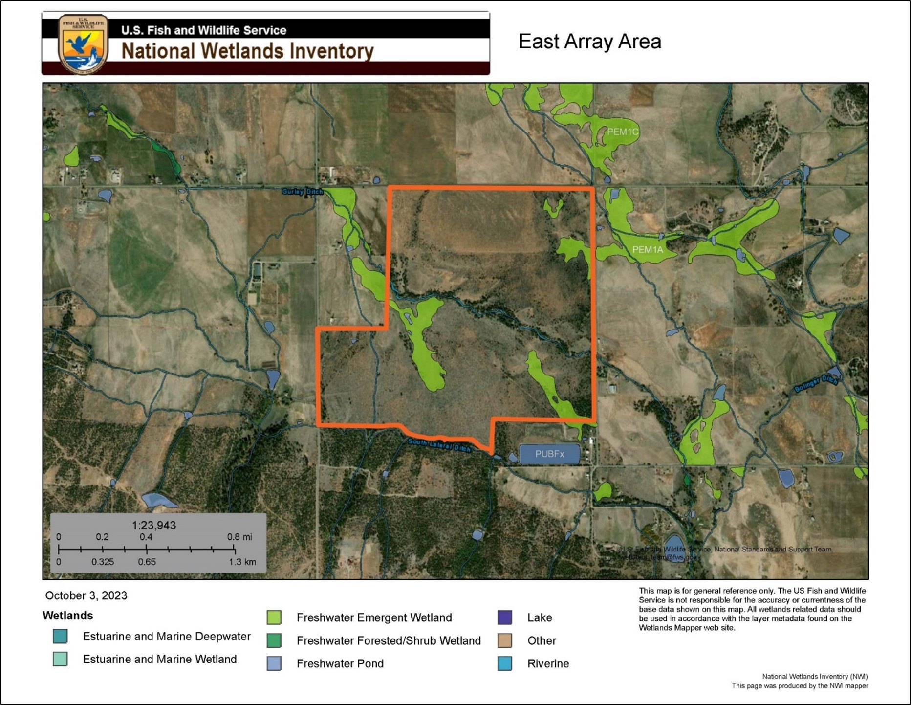
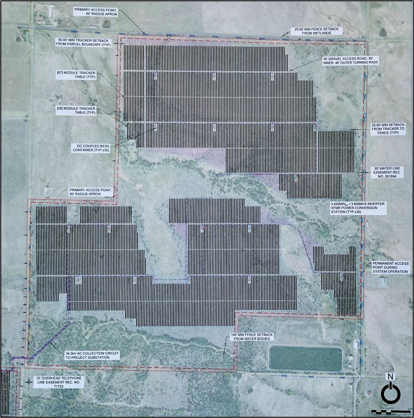
Numerous surface water features occur within the proposed Section 1 east array area. The Gurley Ditch and the South Lateral Ditch, two integral segments of Norwood’s water system, transect the tract. A freshwater spring and marsh, a small drainage, and numerous wetland areas also occur within the SLB tract. According to the informative flyers provided at the May 16, 2023, meeting (Appendix A) and the Project website (About the Project | Wright's Mesa Solar (wrightsmesasolar.com)) the east array would be built over at least one surface water drainage and a small pond (Appendix A); the Project would avoid Gurley Ditch, the South Lateral Ditch, and most of the wetland areas within the SLB tract.
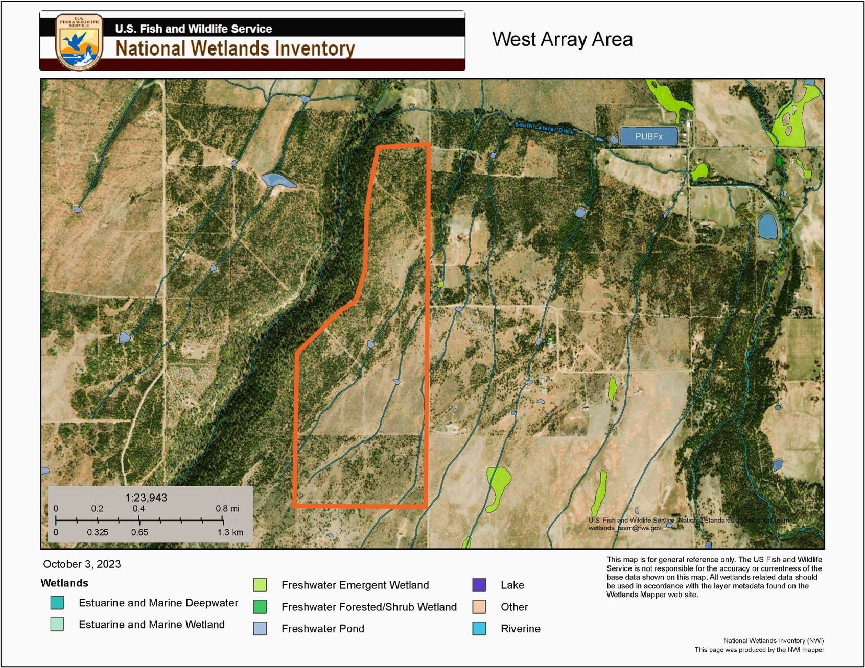
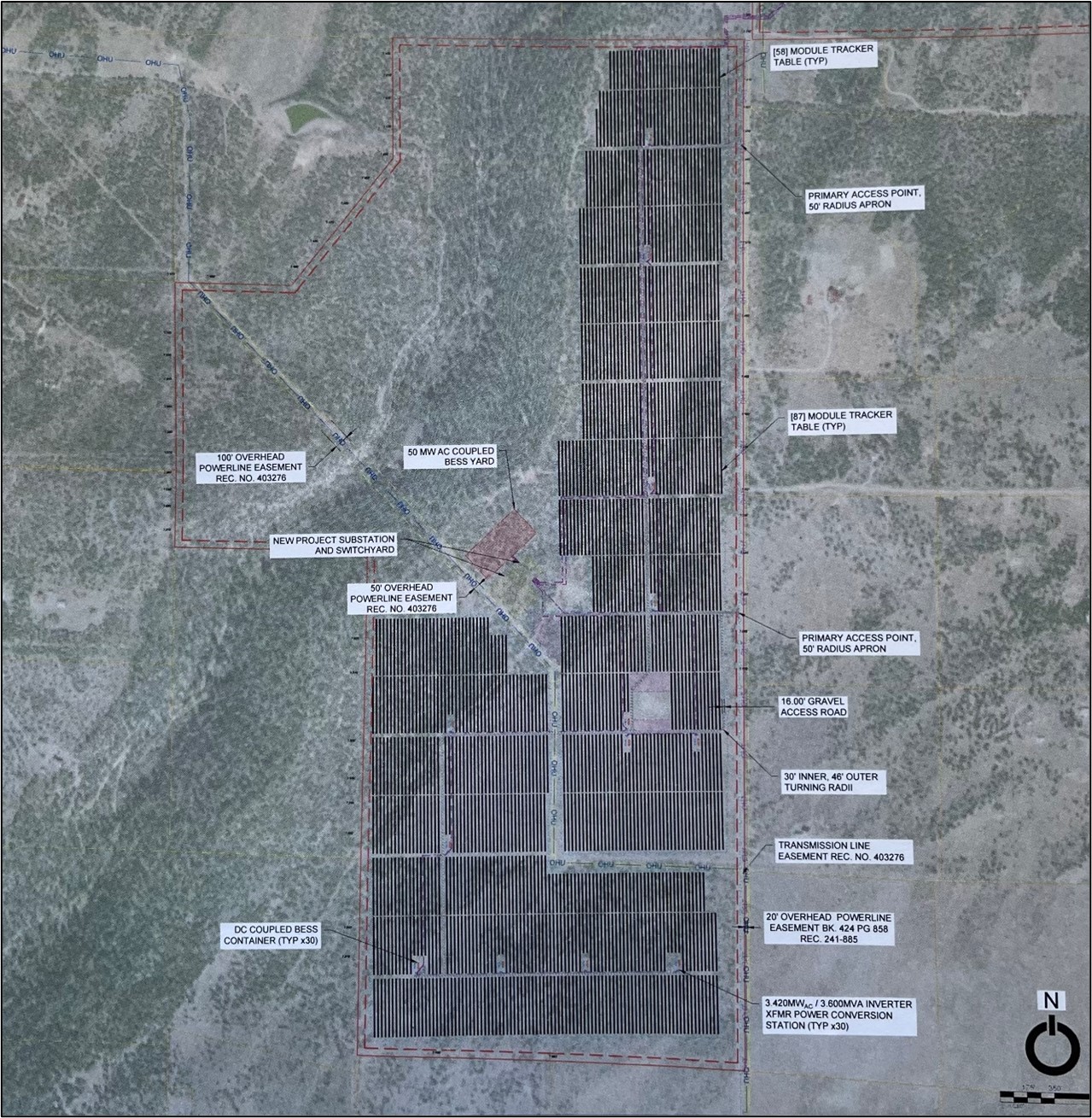
Three channels which come off of the South Lateral and two ponds occur within the proposed Section 2 west array area. According to the Project website and the information flyer, the array would be constructed to avoid the two ponds and be built over the channels (Appendix A).
Norwood Water Supply
Water resources in the Project area are managed by the Norwood Water Commission. The Norwood Water Commission serves an area defined by Beaver Creek on the east side of Wright’s Mesa, Oak Hill on the south, Naturita Creek on the south and west and the San Miguel River on the north and east side of the mesa. The Norwood Water Commission derives most of its water supply from the Farmers Water Development Company (Farmers Water) system, which manages the Gurley Ditch and Reservoir. The Gurley system diverts water from Beaver Creek through the Gurley Ditch to Gurley Reservoir. Gurley Reservoir holds 9,000 AF of water, which is delivered to users through a series of canals, and irrigates approximately 20,000 acres. The Gurley system flow is reliant on annual precipitation, primarily snowfall in the mountains above Beaver Creek. The Gurley flow is not perennial, with water being delivered during specific times: the irrigation season, generally from April 15-May 1 through October 1 (about 20 to 22 weeks per year); upon request after this time until January 15 for domestic uses (e.g. stock watering); one domestic "run" about the first of November. (Norwood Chamber of Commerce, 2000; San Miguel Watershed Coalition, 2000)
Norwood currently holds 119 shares of water which provide the town of Norwood with 286 AF of water during average years and 119 AF during dry years. Because of concerns over expanding the municipal use within the system, the Town is not likely to be able to acquire more shares from Farmers Water. By-laws of Farmers Water set forth the rules for how company water rights are administered and distributed to shareholders. Each shareholder is entitled to a prorata portion of the water and storage available to the company under water rights and available annual supply. Under both the decree and the by-laws, the water use is limited to domestic and irrigation uses. (San Miguel Watershed Coalition, 2000.)
In addition to the Farmer's Water Development Company shares, the Norwood Water Commission also relies upon the water rights listed in Table 3-1. These water rights deliver an average annual yield of 266.5 AF during an average year, and 79.9 AF during a dry year.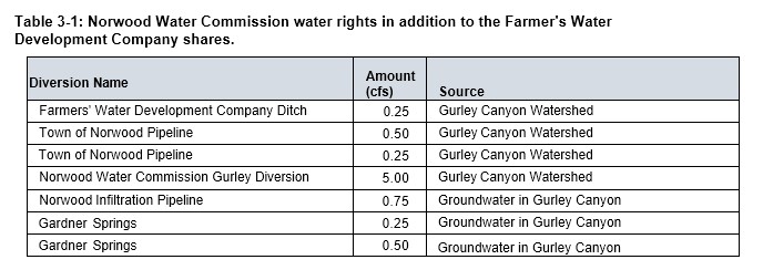
The Norwood Water Commission diverts its water supply at its treatment plant, or stores it in either one of two reservoirs: Reservoir 1 is used for fire protection, Reservoir 2 stores 200,000 gallons of treated water for municipal use. Reservoir 2 and the treatment plant are located on the southeast corner of the SLB property, adjacent to the proposed Project area. Reservoir 2 and the treatment plant are held under a perpetual lease with the SLB (Norwood Chamber of Commerce, 2000; San Miguel Watershed Coalition, 2000).
Ground Water
According to the U. S. Department of Agriculture (USDA) Natural Resources Conservation Service (NRCS) Web Soil Survey (USDA, 2023), the depth to the water table throughout the Project area is greater than 78.74 inches. The Project area and much of San Miguel County is underlain by the Dakota-Glen Canyon aquifer system, which is part of the Colorado Plateau Aquifer region, a system that underlies an area of approximately 110,000 square miles in western Colorado, northwestern New Mexico, northeastern Arizona, and eastern Utah. The depth to the top of the aquifer is less than 2,000 ft in many areas. (Robson and Banta, 1995).
Wetlands
Information and imagery regarding wetlands were gathered at:
- USFWS National Wetlands Inventory mapping program. Available at: Wetlands Mapper | U.S. Fish & Wildlife Service (fws.gov)
Observations made during field investigations corroborated general locations of water and wetland features as indicated by the NWI database. Access to conduct field investigations of the SLB tract was granted via the current agricultural lease holder (personal communications Mont Snyder, 2023). All information and descriptions of conditions in the Section 2 west array area were gathered from the USFWS NWI mapping site, Google Earth (2023) or visually from points along Lone Cone Road. As the proposed west array area is privately held, no onsite investigation was conducted in the west array area.
A jurisdictional wetland delineation as prescribed by the U. S. Corps of Engineers has not been conducted for the Project areas.
East Array
Freshwater emergent wetland areas and riparian zones occur in the east array area. Based on the information flyers distributed at the May 16, 2023 meeting, it appears that the layout of the east array would avoid most of the wetland areas. However, some areas may be impacted by the proposed installation. At least one of the channels in the east array area could be covered by the solar array. Specific information regarding potential access roads needed for construction activities which could potentially impact wetlands and channels, is not indicated in any of the Project information. See Figures 5 and 6.
West Array
Two ponds and two channels occur in the west array area. Based on the information flyers, it appears that the layout of the west array would avoid the ponds, but would cover the channels. Specific information regarding potential access roads needed for construction activities which could potentially impact wetlands and channels, is not indicated in any of the Project information. See Figures 7 and 8.
Consequences
Water is a critical resource on Wright’s Mesa and for the town of Norwood. Annual availability is limited and water quality is critical to sustain agricultural and residential use. According to the by-laws of Farmers Water, the water use is limited to domestic and irrigation uses. There are no shares available for industrial activity. The proposed Section 1 east array area is situated on either side of the Gurley Ditch (see Figure x), upstream from most of the agricultural fields on Wright’s Mesa and the town of Norwood. Any project-related impacts to surface waters would affect most of the water rights on the Mesa.
Project construction, operation, maintenance and decommissioning involves use of numerous chemicals, fuels and other hazardous materials (HAZMAT). Safety data sheets for Project HAZMAT are not available on the project website. Spill contingency plans and stormwater runoff management plans were not presented during the May 16, 2023, meeting, nor are they available on the Project website. Projects such as the proposed are required to develop a Stormwater Pollution Prevention Plan (SWPPP) and a Spill Prevention Control and Countermeasure Plan (SPCC) to minimize potential adverse effects to water resources. The SWPPP and SPCC develop site-specific erosion control measures and hazardous materials handling and spill contingency plans. Measures would be implemented throughout all phases other Project to minimize impacts to surface and ground water resources.
Continuous soil disturbance and vehicle and equipment operations during construction are likely to increase sedimentation and surface runoff. Increased total suspended solids in surface waters could occur during construction during seasonal releases from the Gurley Reservoir through the Gurley Ditch and the South Lateral Ditch. Any runoff into these conveyances would impact water quality downstream. It is anticipated that the SWPPP for the Project would include measures to minimize surface runoff into area streams.
Over the course of the Project life of 30 years, direct adverse effects to water quality are likely. Adverse impacts to water quality downstream could occur from sedimentation during construction and unintentional release of hazardous chemicals over the course of the 30-year life of the project from construction through operations. Potential impacts to ground water could occur from unintentional release of hazardous chemicals over the course of the 30-year life of the project from construction through operations. Project permitting requires that appropriate spill contingency plans are prepared and implemented to minimize potential for impacts to surface and ground water resources. Based on the implementation if SWPP and SPCC, it is anticipated that adverse effects to water resources would be minimized but cannot be completely eliminated. The proposed project would result in direct adverse impacts to water resources. The level of impact could range from significant to minor, and is dependent on the type of event (i.e., sediment runoff, HAZMAT spill), the effectiveness of remediation, and timing of the spill events relative to seasonal water releases.
No Action Alternative
The No Action Alternative would result in no impacts to water resources and water quality because the Project would not be constructed.